TYPOLOGY
Inverse Models
CONTACT POINT
Jorge RUIZ
ROLE
PhD Candidate
jorge.ruiz@fmi.fi
support@eo-wimex.eu
Phase2Snow
The Inverse Model for Snow Phase Signature inverse the observed phase change due to snow changes between the InSAR pairs using the model proposed by Guneriussen et al 2001. The model is based on the increase in the optical path and travel time in presence of snow, as snow has a higher permittivity than air. The inversion of the model requires the following inputs: SAR central frequency, interferometric phase, Local Incidence Angle (LIA) and Snow Density. This module produces a map in GEOTIFF format with the inverted interferometric phase.
The figure below depicts a representation of the model for phase change from snow change [1,2]. The line
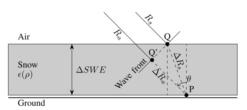
The phase signature is calculated as [1]:

The inversion of the phase in terms of ΔSWE is:

- κ i is the incoming radar beam vector.
- ΔZ s is the snow depth change (m).
- θ is the local incidence angle (m).
- ρ s is the snow density (
No datacube available for this model.
InSAR: Interferometric Synthetic Aperture Radar
SWE: Snow Water Equivalent
[1]. T. Guneriussen, K. A. Hogda, H. Johnsen, and I. Lauknes, “InSAR for estimation of changes in snow water equivalent of dry snow,” in Proc. IEEE Int. Geosci. Remote Sens. Symp. Taking Pulse Planet, Role Remote Sens. Manag. Environ. (IGARSS), vol. 2, Oct. 2000, pp. 463–466.
[2]. Leinss, Silvan & Wiesmann, Andreas & Lemmetyinen, Juha & Hajnsek, I.. (2015). Snow Water Equivalent of Dry Snow Measured by Differential Interferometry. IEEE Journal of Selected Topics in Applied Earth Observations and Remote Sensing. 8. 1-18. 10.1109/JSTARS.2015.2432031.